Mining and Mineral Exploration with Hyperspectral Imaging Solutions

Image 1: High energy costs, complex ore bodies, and strict environmental standards challenge today’s mining operations. Hyperspectral imaging (HSI) provides detailed mineral insights that enable smarter exploration, greater automation, and more sustainable production.
Hyperspectral imaging accelerates mineral exploration
In today’s fast-moving exploration environment, hyperspectral imaging (HSI) has become a key technology for mining and mineral exploration. Specim’s advanced hyperspectral imaging solutions empower geologists and exploration teams to detect, analyze, and map mineral deposits faster and with higher accuracy — from early surveys to detailed drill-core studies.
By capturing detailed spectral data invisible to the human eye, hyperspectral imaging transforms how exploration projects are executed. It enables rapid, objective, and repeatable mineral identification across large areas — from surface outcrops to core trays — helping teams make smarter, data-driven exploration decisions.
Key benefits of hyperspectral imaging in mineral exploration:
- Objective mineral mapping across entire outcrops and drill cores
- Faster turnaround in core logging and alteration mapping
- Improved target accuracy, reducing unnecessary drilling
- Quantitative validation with spectral libraries and field spectra
- Detection and mapping of alteration halos
- Integration with geophysics and geochemistry for comprehensive geological insight

Image 2: 3D geological modelling and analysis. Image courtesy of GeoSpectral Imaging.
Hyperspectral vs. multispectral imaging in exploration
Understanding the difference between hyperspectral and multispectral imaging is crucial for exploration success.
Multispectral imaging mining applications:
- Captures only a few broad wavelength bands (typically 5–15)
- Suitable for reconnaissance-level mapping and alteration zoning
- Limited capability for detailed mineral identification
Hyperspectral imaging mining applications:
- Collects hundreds of narrow, contiguous spectral bands
- Enables precise detection and discrimination of specific minerals and mixtures
- Provides quantitative and repeatable mineralogical information
With hyperspectral data, exploration teams gain laboratory-level mineral detail directly from field or core samples — dramatically increasing efficiency and confidence in exploration targeting.
Full-spectrum hyperspectral imaging coverage for mining exploration
Specim is the only manufacturer offering hyperspectral imaging systems that cover the full spectral range — from visible (VNIR) to thermal infrared (LWIR). This enables unmatched flexibility in geological and mining applications.
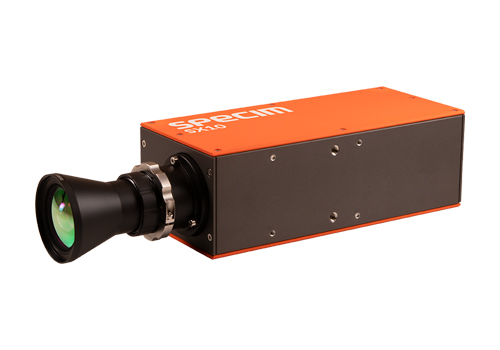
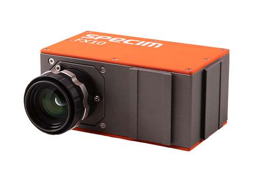


Key wavelength ranges for mineral exploration:
VNIR (400–1000 nm):
Visible and Near-Infrared (VNIR) range is ideal for mapping iron oxides (hematite, goethite), vegetation, and oxidation zones. Useful for early-stage alteration detection and preliminary rare-earth element (REE) studies.
SWIR (1000–2500 nm):
Short-wave infrared (SWIR) range is the most widely used range in exploration — critical for detecting clays, carbonates, and hydrothermal alteration. Especially relevant for porphyry, epithermal, and sediment-hosted systems.
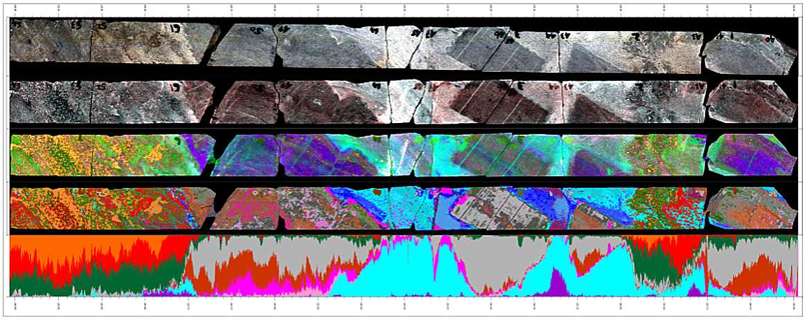
Image 3: SWIR example – skarn deposit. From top: RGB image, False color SWIR, Enhanced SWIR, Spectral facies SWIR, Spectral facies percentile log. Image courtesy of GeoSpectral Imaging.
MWIR (2.7–5.3 µm):
Mid-wave infrared (MWIR) detects hydrated minerals and hydrocarbons, expanding the range of geological and environmental applications.
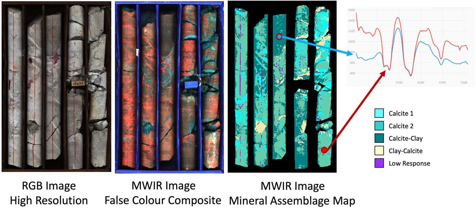
Image 4: Example of mid-wave infrared (MWIR) hyperspectral imaging of drill core samples – Image courtesy of TerraCore.
LWIR (7.7–12.3 µm):
Long-wave infrared (LWIR) hyperspectral imaging captures emissivity-based data for silicates like quartz and feldspars, enabling lithological discrimination and mapping of major rock-forming minerals.
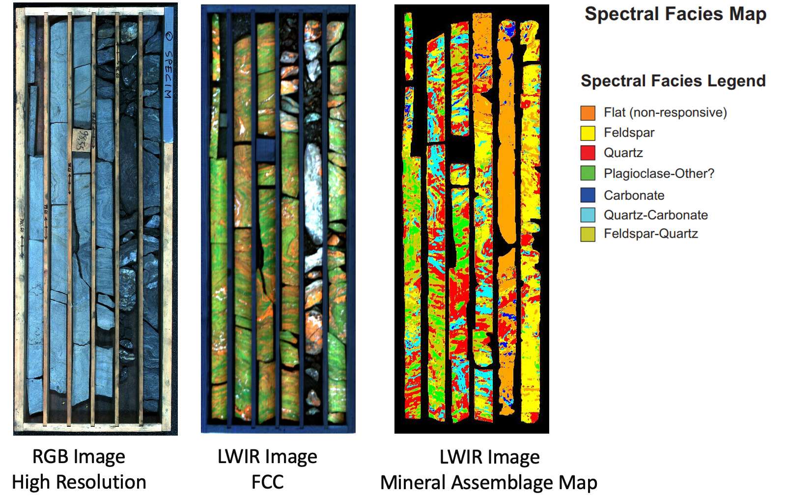
Image 5: Example of long-wave infrared (LWIR) hyperspectral imaging of drill core samples Image courtesy of TerraCore.
Mapping mineral outcrops and rare-earth deposits
Advances in spectral geology and drone-based imaging have made it possible to map mining outcrops and identify rare-earth deposits with exceptional precision. Hyperspectral imaging — deployed via aircraft, drones, or ground-based scanners — delivers consistent and high-resolution mineral data for exploration targeting and geometallurgy.
In open-pit quarries, hyperspectral imaging is used to map mine walls in three dimensions using drones or tripod-mounted scanners. These digital outcrop models, enriched with hyperspectral reflectance data — also known as hyperclouds — provide spatially continuous mineralogical information across exposed rock faces. This enables geologists to interpret mineralization processes, link surface data with drillhole results, and support smarter, data-driven extraction strategies.
Using machine learning and spectral libraries, these 3D datasets can be analyzed to automatically map lithologies and alteration zones, offering an efficient, quantitative way to monitor and optimize mining operations from a safe distance.
Using the best hyperspectral imaging systems and drones for mining and mineral exploration, geologists can now access large, remote, or hazardous sites quickly, reducing survey time and cost.

Image 6. Mapping and characterizing a mineral deposit with hyperspectral data. The left panels show hyperspectral, RGB, and mineral interpretation views, while the right plots reveal correlations between spectral data and geochemical results — where certain mineral patterns indicate zones of high gold content. This shows how hyperspectral methods can efficiently identify gold-rich areas without extensive and costly geochemical sampling. Image courtesy of GeoSpectral Imaging.
Minerals commonly detected with hyperspectral imaging:
- Iron oxides (hematite, goethite)
- Rare Earth Elements (REEs)
- Clays (kaolinite, illite, montmorillonite)
- Carbonates (calcite, dolomite)
- Sulfates (alunite, gypsum)
- Silica (quartz)
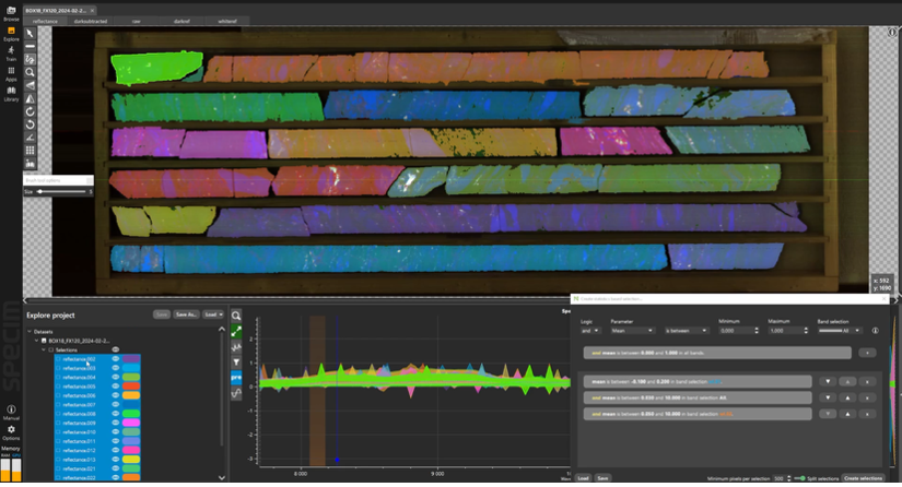
Image 7. Analyzing drill core hyperspectral data with SpecimINSIGHT software.
Whether assessing surface outcrops or analyzing drill cores, Specim’s solutions deliver consistent, quantitative data for every stage of mineral exploration.

Image 8: The Infrared Mineral Identification table by TerraCore summarizes which parts of the infrared spectrum (VNIR, SWIR, MWIR, LWIR) are most effective for identifying different mineral groups. It helps geologists and hyperspectral imaging users understand guiding instrument and wavelength selection for mineral exploration and geological analysis. For more information, visit TerraCore.
Proven solutions for mining exploration workflows
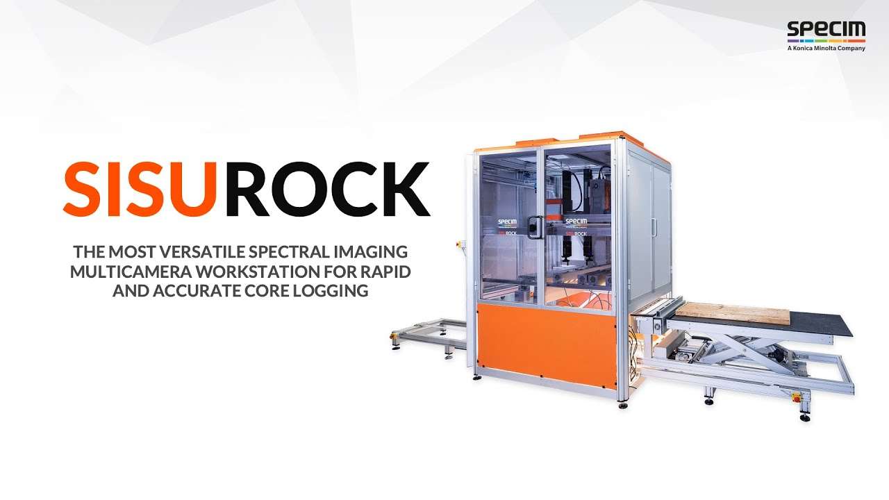
The Specim SisuROCK is an industry-leading hyperspectral imaging workstation for geological and mining exploration. It delivers fast and reliable results for core scanning, mineral mapping, and spectral validation — all compatible with Specim’s complete camera range: VNIR, SWIR, MWIR, and LWIR.
It also features an RGB camera and a 3D imager, enabling true-color visualization and surface topography analysis alongside hyperspectral data. This integrated approach provides a complete understanding of core and outcrop samples — from texture and structure to mineral composition — helping geologists make faster and more informed exploration decisions.
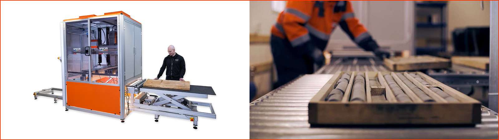
Image 9: Specim SisuROCK is a scientifically proven and reliable spectral imaging instrument that significantly improves the efficiency and productivity of drill core analysis and mineral mapping.
For airborne and drone-based exploration, the Specim AFX series enables lightweight, high-resolution remote sensing — ideal for mapping large or hard-to-reach areas.
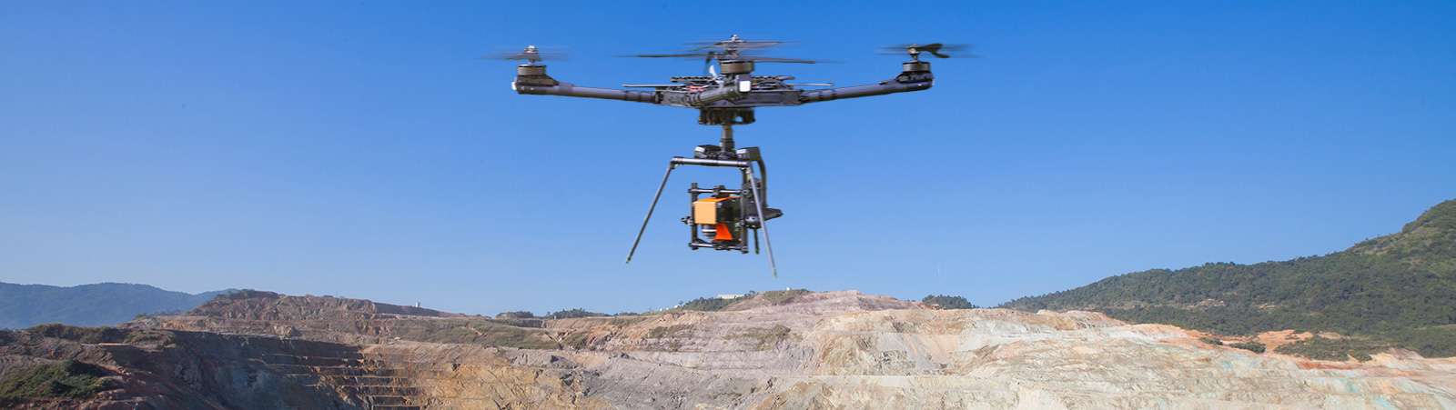
Image 10: Specim AFX is a compact, all-in-one airborne hyperspectral imaging system for drones, combining a hyperspectral camera, a powerful computer, and a high-end GNSS/IMU unit into a single, easy-to-mount enclosure.
👉 Find out more about the SisuROCK workstation
👉 Learn about Specim AFX hyperspectral imaging for drones
FAQs: Hyperspectral imaging in mining and mineral exploration
💬 How do mining companies find mineral deposits?
Exploration teams combine geological, geophysical, and geochemical data with hyperspectral imaging to detect mineral signatures that traditional methods may miss. By identifying unique spectral fingerprints, hyperspectral imaging speeds up mineral discovery and reduces exploration costs.
💬 How does hyperspectral imaging assist mineral exploration?
HSI provides detailed, quantitative mineral maps across outcrops, cores, and mine walls. It helps identify alteration zones, track fluid pathways, and guide drilling decisions based on spectral mineralogy.
💬 What makes Specim’s hyperspectral imaging unique for mining exploration?
Specim offers the industry’s most complete hyperspectral imaging portfolio, covering the full VNIR–LWIR spectral range and supporting all exploration phases — from early reconnaissance to processing optimization.
Specim provides laboratory and remote sensing solutions, including hyperspectral cameras, scanners, and software for consistent, quantitative results across the entire exploration workflow — from core analysis in the lab to airborne, drone, and tripod-based surveys in the field.
💬 How can hyperspectral imaging be used in active mining operations?
Mounted on vehicles, conveyors, or drones, hyperspectral systems monitor ore quality, detect deleterious materials, and support process optimization for cleaner, more efficient mining.
Why choose Specim for mining and mineral exploration
With decades of expertise and a proven track record in geological and mining applications, Specim enables organizations to transition from qualitative assessment to quantitative, data-driven exploration. Trusted by partners like Terracore, Specim provides the technology foundation for more accurate mapping, faster decisions, and reduced exploration risk.
Start your journey toward smarter mineral exploration
Experience the power of full-spectrum hyperspectral imaging in your next mineral exploration project. Contact us for a consultation, demo or feasibility study.